 GOVERNMENT
OF INDIA
GOVERNMENT
OF INDIA
A Digital India Initiative
GOVERNMENT
OF INDIA


Satna is a major city in the Indian state of Madhya Pradesh. It serves as the headquarters of the Satna district. It is the 6th largest city and the 8th most populous city of the state. The city is 500 km east of the state capital Bhopal.
An analysis was done to understand the increase in the area covered under the city so as to be better prepared for the upcoming urbanization.
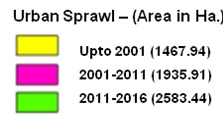
Till 2001, the urban area was 1467. 94 ha. as highlighted in the below map.
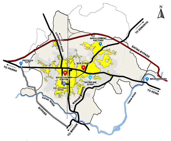
From 2001 to 2011, it was seen that the residential area of the city increased to 1935.91 ha. due to the influx of people from surrounding areas as well as the increase in population. The growth of the city during 2001 to 2011 is shown in the below map.

Further, from 2011 to 2016, it has been found that the residential area increased to 2583.44 ha. as shown in the below map.
It is projected that in the coming times, it will continue to grow like this, and thus the area of Satna will continue to convert into a residential area. Along with this, we plan to further analyze more things such as the speed at which the population is increasing so as to understand the expected increase in the residential area.
Further, the municipal area has increased to 71.67 square kms area in 2020 spanning 45 wards, and the population has increased to 3,14,256. By 2026, this area is projected to increase to 86.04 square kms covering around 50 wards, and the projected population is likely to be upto 3,45,000.
Thus, the analysis of spread in the residential area is helping the city understand and prepare for the future needs of its population with respect to all the services including water supply, sanitation, lighting, revenue management, administrative services, etc.