 GOVERNMENT
OF INDIA
GOVERNMENT
OF INDIA
A Digital India Initiative
Please login using your email address as it is mandatory to access all the services of community.data.gov.in
GOVERNMENT
OF INDIA


Business Challenge
The Municipal Corporation of Greater Mumbai (MCGM) covers a total area of 454 sq. km. and caters to a population of 12.43 million according to 2011 census. There are 24 wards under the corporation and more than 75 departments to provide various services to citizens of Mumbai.
Being the largest City of India, with a high density of population 20,634 person/sq. km., the major challenge is to meet the increasing demands of governance and service delivery for the citizens.
To improve service delivery, MCGM embarked on an ambitious e-Government initiative, aimed at enhancing responsiveness to citizens’ needs; increasing operating efficiency and effectiveness; improving financial health; and ensuring greater transparency within various departments like Sewerage Operations, Disaster Management, Environmental Department and Public Health Department.
There were challenges like:
Primarily, MCGM wanted to provide citizen services through a GIS portal and improve inter-department collaboration.
Solution
GIS provides a common communication language to the different stakeholders of a city, it provides a language to citizens to interact with government.
Thus, a digitised map of Greater Mumbai was created by digitizing Tikka and Town Planning scheme images. Land parcels and roads were digitised, followed by scanning and digitising of 6,000+ images to capture different features of the city, incorporating the development plan for 20 years, all major utilities, revenue elements and social infrastructure, to have an integrated database for better planning and management, and sustainable development of the city.
Esri GIS Integrator was envisaged to bring all MCGM GIS data and applications to a collaborative GIS content sharing platform. Desktop GIS applications were deployed in 2008 for generating Development Plan remarks for department users. MCGM Development Plan Department launched the OneMCGM Portal which is used by the MCGM internal users. The Portal host all the GIS data of different departments and web applications that are shared across the user base.
In five departments GIS was used to design, migrate/implement and maintain GIS data and web applications for end-to-end asset management. These Departments are Sewerage Operations, Roads and Traffic, Hydraulic Engineering, Storm Water Drainage and Bridges. 35 layers of GIS information have been crated in OneMCGM portal for catering to the requirements of these departments.
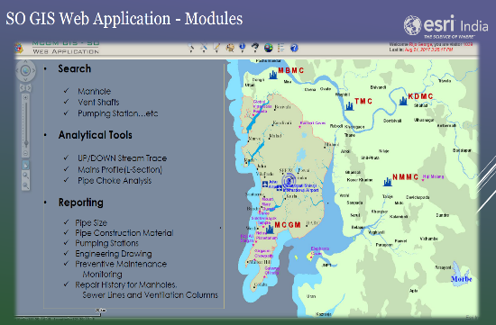
Sewage Operation Department: SO department manages the entire Sewerage network within the City and the Suburbs of MCGM area. Application Tools for location-based management include:
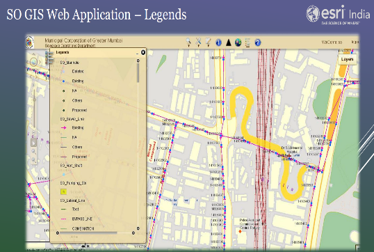
SO Department Web Application – Legend
SO Department Web Application – Modules
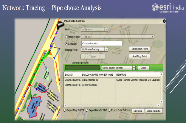
SO Department Web Application – Network Analysis
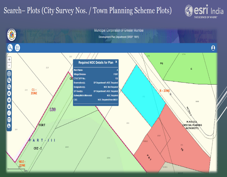
Development Department Remarks Generation: Development Department plans and implements the Development Plan (DP) for the city of Mumbai. Each development plan spans 20 years, current one being from 2014-2034. Based on the urban planning and town planning standards and policies, DP plan details the land use across the MCGM area, divided into 24 administrative wards. DP Plan consists details of existing amenities, existing roads, town planning schemes, coastal regulatory zones, land use zones, parcels boundaries, planned amenities, planned roads and road widening information, slum rehabilitation areas, etc. (100+ layers). Remarks Generation Application facilitates:
SRDP1991 – https://dpremarks.mcgm.gov.in/srdp1991
DP2034 – https://dpremarks.mcgm.gov.in/dp2034/
As part of OneMCGM initiative, a Mobile Application for citizens was developed for viewing the various DP reservations.
Integration with SAP: OneMCGM is integrated with different applications running in MCGM to create spatial reports.
1. Integration with Capital Value System (CVS)

2. Integration with Auto DCR system Building Construction Approval Management System (BCAMS) under EODB initiative.
3. Integration with SAP(PS) System for real-time projects monitoring.
4. Integration with SAP-RE System for Real Estate Department.
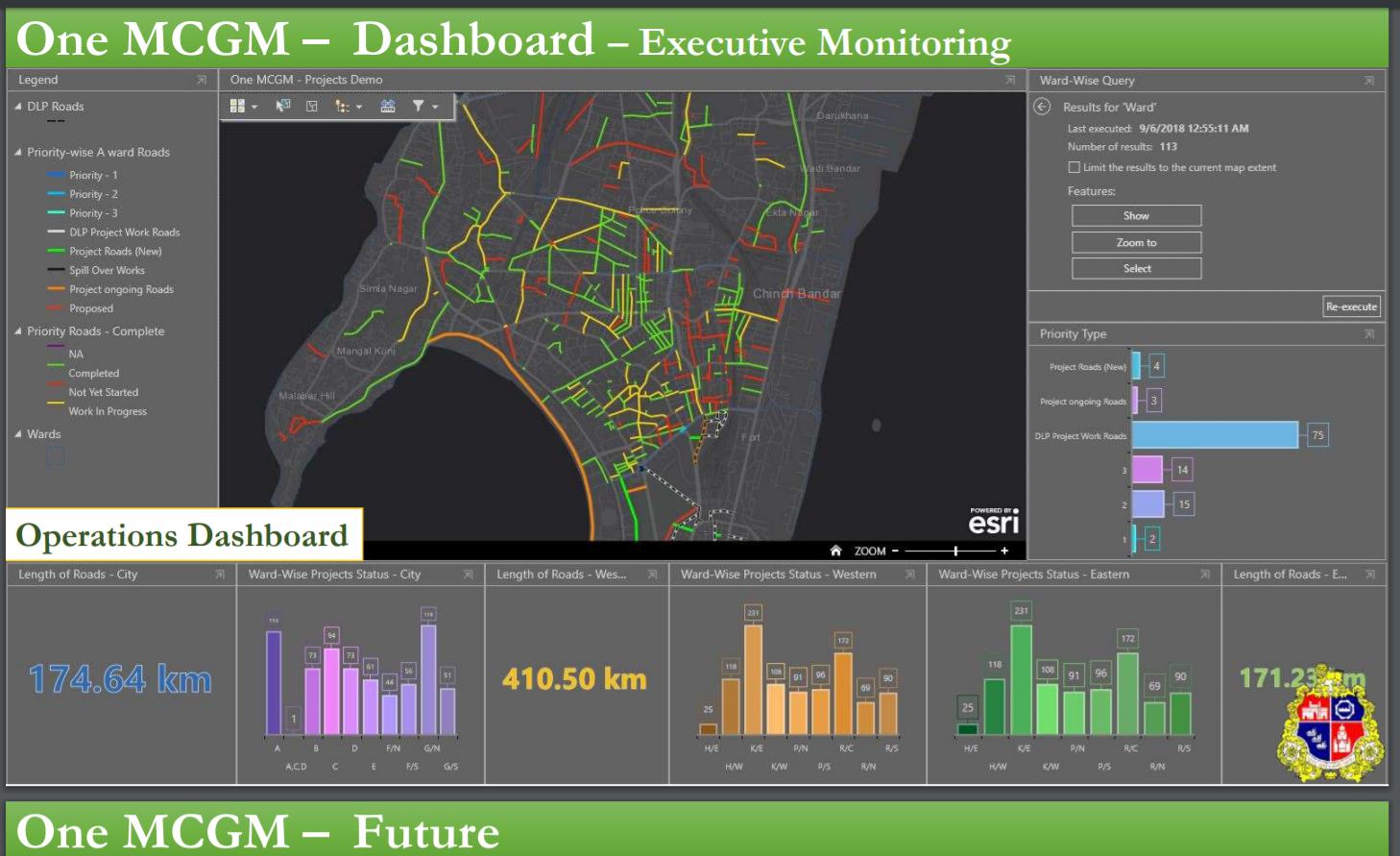
Dashboards: For the executive monitoring a real time operation dashboard has been created.
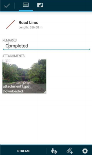
Mobile based Workflow: GIS enabled mobile apps had been created for the MCGM Field staff to view and update project status from the field.
Impact on Citizen Service Delivery
This e-Government initiative would help citizens to request for services in an easier and faster manner, thus resulting in significant savings in cost and time. The Municipality would consequently be in a better position to service its citizens, better monitor and control its activities and introduce Customer Relationship Management (CRM) concepts; resulting in tangible and visible increase in the quality of services for the average citizen.
The ‘One MCGM GIS’ portal displays latest information about various departments of the civic body, which could be mainly utilised by its officials and workers with an aim to speed up decision-making and coordination. Through this application and website, people can get better services.
One MCGM has brought all the applications to one Enterprise GIS Platform
Earlier arrangement required Citizens to visit local ward offices of MCGM to seek the information of DP reservations, city survey number, etc. With the launch of Mobile Application, citizens now can download the app on their mobile phone and using GPS location can view the all details of the plot/DP reservations. It also became a Common Application platform.
Details on current usage of the system
Till date, more than 10,000 Android and iOS users have downloaded and used this application.